UN-GGIM 7th Assembly Endorses the Establishment of a Global Working Group on Marine Geospatial Information
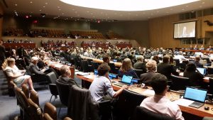
 The United Nations Committee of Experts on Global Geospatial Information Management (UN-GGIM) held its 7th Session in New York on 2-4 August with over 400 delegates and observers attending. UN-GGIM overwhelmingly endorsed the creation of a Global Working Group on Marine Geospatial Information in order to better meet three of its 2030 Sustainable Development Goals namely improving ‘Clean Water and Sanitation’, ‘Industry, Innovation and Infrastructure’ and ‘Life Below Water’.
The proposal was tabled by the US National Oceanographic and Atmospheric Administration (NOAA) Office of Coastal Surveys (OCS) supported by the International Hydrographic Organisation (IHO). In its report to the UN Secretariat, NOAA addressed substantive issues on the marine environment necessary to strengthen global geospatial information management in the marine space. The outcome will assist Member States to develop national policy, strategic priorities, decision making as well as measure and monitor global development outcomes in the world’s oceans and seas.
The Marine Working Group will focus, for example, on the development of a Global Geodetic Reference Frame, Fundamental Data themes such as elevation (water depth) which will enable land-sea data interoperability and the creation of a single ‘skin of the earth’. The Working Group will engage with subject matter experts including the IHO and the UN-GGIM Private Sector Network, of which OceanWise is a member, to achieve its goals.


